
2704 M It is the second largest town in Ladakh after Leh that cultivates Apricots in large quantity & plenty of Wheet & Vegetables . It is a Gateway of Suru & Zanaskar Valley. Kargil is the base camp where from most of the adventures trek orginate it also offers thrilling opportunities of Rafting Camping & mountaineering. Present-day Kargil was not the natural capital of the region, or Purig as it was also known. Earlier, Purig consisted of a number of small but independent kingdoms, which included Chiktan, Phokhar, Sot and the Suru Valley.It is said that it was the period of Ali Sher Khan Anchan, the famous ruler of Skardu, in the late 16th and early 17th centuries which had a great influence on the area. This prince from Baltistan conquered most of the principalities of Purig and introduced Balti culture in the Kargil district Summers are hot with cool nights, while winters are long and chilly with temperatures often dropping to −48 °C People in Kargil are of mixed Dard and Tibetan descent.Today, 90% of Kargil’s population are Shia Muslim, 5% Sunni and 5% Tibetan Buddhist. The architecture of older mosques in Kargil combines Tibetan and Iranian styles, while newer mosques architectural styles tend to follow those of modern Iranian and Arabic styles.
Drass:
268 Km 3230 M It is often called ‘The Gateway to Ladakh’ 60 km west of Kargil on the Srinagar leh Highway is said to be the secont coldest in habited place in the world.This valley inhabited by Dards also knows as Drok-pa hwo speaks Shina Language & belong to the tribes from Gilgit. The Famous tiges hill is clearly visible from the main highway in Drass village. Dras is a convenient base for a 3-day long trek to the Suru valley across the sub-range separating the two valleys. This trek passes through some of the most beautiful upland villages and flower sprinkled meadows on both sides of the 4500m Umbala pass, which is along the way. The trek to the holy cave of Amarnath (in neighbouring Kashmir) starts from Minamarg below Zojila, takes three days and involves crossing a pass at 5200m. Dras also offers numerous shorter treks and hikes to the upland villages. Dras experiences an altitude-influenced subarctic climate. Winters are extremely harsh with average lows around −22 °C and as low as −45 °C at the height of winter, which lasts from mid-October to mid-May. Summers start in June and go on up till early September, with average temperatures near 15 °C and little precipitation.
Mulbek:
45 km 3230 M Situated 45 kms east of Kargil on the road to Leh, is a predominantly Buddhist area.Many monuments of the early Buddhist era dot the landscape among which the chief attraction is Mulbek Chamba, a 9 m high rock sculpture in deep relief of the Maitreya, the “Future Buddha”, which reflects a unique blend of esoteric Saivite symbolism, with early Buddhist art. Situated right on the highway Mulbek gompa, the main monastery of the area is perched atop a rocky hill that dominates the valley below. It is easy to see why in the past this site served as an outpost to guard the caravan route between Kashmir and Ladakh.
Shergol – Another picturesque village of the area, Shergol has a mixed opulation of Muslims and Buddhists, and can be approached through a link road from the main highway. The main attraction for visitors is a cave monastery visible from afar as a white speck against the vertically rising brown hillside, from which it appears to hang out. Down below is a Buddhist nunnery with about a dozen incumbent. There is an interesting 4- day trek from here into the Suru Valley across two mountain passes, Safi-la and Rusi-la. Urgyan-Dzong, a meditation retreat tucked deep inside the surrounding mountains, can also be approached via the nearby village of Pho-khar. This natural mountain fortress conceals a circular tableland with a small Buddhist temple .
Suru Valley:
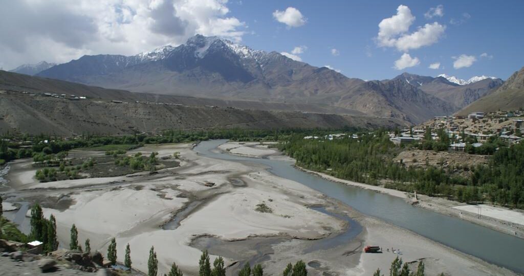
140 Km 7000 M One of the most beautiful regions of Ladakh, the Suru Valley is the heartland of Kargil district. Nestling along the northern foothills of the Great Himalayan Wall,white topped mountain peaks of the Nun-Kun massif, are visible from several places in the valley. The lower part of the valley, is one of the most agriculturally productive parts of Ladakh with two crops a year being harvested, watered by the run-off from the very heavy winter snowfalls and even plantations of willow and poplar trees making it a relatively lush and very attractive area, but around Rangdum the landscapes are stark, flat moor lands ringed by arid crags. The spiky The upper reaches of the valley, particularly around the Sankoo bowl, the expanse around Panikhar and the higher stretches beyond, present a spectacle of breathtaking features – majestic mountain ranges crowned by snow-capped peaks, alpine slopes drained by wild mountain streams of pristine water, awesome glaciers descending along the Himalayan slopes to the river bed in impressive formations, quaint villages of adobe houses straggling dry hillocks, which are generally surrounded by cultivated fields and alpine pastures uphill. Trespone area (25 kms) is famous for its hilltop Imambara, which reflects a quaint mix of Islamic and Tibetan elements in its construction style and location. Sankoo (42 kms), the next major expanse of the Suru Valley, is a picturesque township surrounded with numerous villages and colourful rocky mountains all around. Dense plantation of poplars, willows and wild roses fill the bowl-shaped valley, giving it the ambience of a man-made forest. Two side valleys drained by large tributary streams of the Suru River, the Kartse flowing from the east and the Nakpo-chudescending from the west, open up on either side of the expanse. Panikhar :25 kms further ahead of Sankoo is Panikhar, lying under the shadows of the Nun-Kun massif. The first full photogenic view of Mt. Nun (7135 m), however, can be had from the roadside near the village of Thangbu, about 12 kms short of Panikhar. A beautiful expanse of the Suru Valley with about a dozen villages strung around, Panikhar comprises a series of intensively cultivated plateaux, descending in level steps, to the bed of the Suru River which here receives the gushing waters of Chelong River, one of its major Himalayan tributaries. During summer the area is converted into a veritable valley of flowers when a variety of alpine flora blossom, lending the region a colourful hue.
Zanskar:
6000 M The Zanskar Range is a mountain range that separates Zanskar from Ladakh.Zanskar appears as “Zangskar” the name reveals that its origin might refer to the natural occurrence of copper in this region, the Tibetan word for which is “Zangs”. Zanskar is a high altitude semi-desert lying on the Northern flank of the Great Himalayan Range. Parts of Zanskar valley are considered some of the coldest continually inhabited places in the world. Its main occupations are cattle-rearing and farming of land that they almost always own. Cultivable land is scarce, and restricted to alluvial fans and terraces, The Zanskar river joins the Indus in Ladakh. High mountain ridges lie on both sides of the Doda and Lingti–kargyag valleys.To the south-west is the Great Himalayan Range which separates Zanskar from the Kisthwar and Chamba basins. The only outlet for the whole Zanskar hydrographic system is thus the Zanskar river, which cuts the deep and narrow Zanskar Gorge through the Zanskar range. For locals and trekkers alike, the Shingo La is technically one of the easiest 5000m passes in Indian Himalaya, involving no glacier trekking nor steep climb.The wildlife that can be found in Zanskar are the marmot, bear, wolf, snow leopard, kiang, bharal, alpine ibex, wild sheep and goats, and the lammer geier. The yak, is of paramount importance in Zanskar. The Frozen Zanskar river is used as Short route to reach Nimmo called Chaddar Trek Particularly in Feb month Trekkers can find limited provision in the villages along the valley. There are no petrol stations in Zanskar, so motorcyclists should bring all the fuel they need in spare cans.
Padam:
240km 3505 M It is 240 km away via the link road from Kargil town .Padum is named after Padmasambhava. It is the only town and administrative centre in Zanskar. It was historically one of the two main capitals of the Zanskar Kingdom, the other being Zangla..it has a large no of Muslim Community whose origin dates back to 17th Century . Padum is at the centre of the tri armed Zanskar valley A number of notable Buddhist monasteries are located near Padum including Bardan Monastery and Kursha Monastery and the newly built Dalai Lama Photang.
Lamayuru:
( Moon Land) 127 Km Renowned as Tharpa Ling which means the ‘place of freedom’; Lamayuru monastery is the oldest and one of the largest monasteries in Ladakh . It is located approximately 127 km from Leh on a steep mountain between Bodhkharbu and Kha-la-che.The monastery is famous for its rich wall paintings, collection of thangkas, murals, scriptures and statues of different forms of Buddha and other deities. It was predicted that the lake would be dried and a monastery would be constructed at its place. When the lake dried, Naropa found a dead lion there and chose to construct first temple of Singhe Ghang (Lion Mound). He constructed five buildings but only one exists. Besides its monastery, Lamayuru also attracts tourists for its landscape quite similar to the lunar terrain. Though remote, the landscape is a favourite with photographers and trekkers. The annual festival known as Yuru Kabgyat is the major attraction of the monastery. Mask dance by the lamas are the highlight of the festival. Another important ritual followed during the festival is the burning of effigies. It stands for destruction of the ego in every individual.